Foreword:
In medieval era, cities were feudal in nature. Their urban diagrams represented power and strong order in terms of class/caste based segregation. Cities were conceptualized with idea of huge surplus through agriculture. This surplus gave large number of merchants who started becoming dominating people in the cities due to wealth. They used to set up the markets and the market places started becoming dominating place, which earlier used to be religious places.
Major shift was seen when the human labor was replaced by machines, age of machines took over the human energy. In mid-18th century, James Watt invented Steam Engine. This invention revolutionized the way energy was conceived before. From 1760 to 1820 in Europe, manufacturing process was transformed. The modes of productions changed dramatically post industrial revolution. The development of machines led to rise of the factories. Textiles were one of the leading industrial revolutions of the time. These factories became revolution in its time because they stood on the promise of employment, mass production and huge surplus. In this manner textile industries became epicenters of modern methods of productions. Industrial revolution became benchmark movement in history because all the facets of life were then influenced by it in on or the other way. The lifestyle started becoming dependent on these machines. According to economists, due to industrial revolution, standard of living went high in general population. In addition to this, because of more economic opportunities, people from rural settlements started flooding towards urban areas. In second phase of industrial revolution, between 1840 and 1870 AD, technological and economic progress took it to other level where steam engine was adopted in transport. Steam powered railways, boats and ships made connection of urban areas to other parts of world faster and easier. Where animals and animal carts or sails were used to transport the goods across the globe, machines took over these conventional practices then. Construction of major railways and bridges connecting cities were built in second industrial revolution. These advancement in infrastructure also added up to people migrating towards cities. This rising population needed to be housed in urban precinct somehow. The chaos which happened due to this overflow of urban population in late 19th century was needed response severely. Concept for city planning and imagining the city was required to re-thought and find an answer to this situation. Many European cities like London and Paris went through this phase and they had to undergo a major transformation in order to house the growing needs of the city.
The authorities were required to accommodate migrated people and also supposed to give adequate economic opportunities to them. The factories which opened post industrial revolution were outside the city and people needed to travel every day to factories and come back. This transit oriented lifestyle became a major shift in its kind. Traditionally people used to work from the same place where they lived, which went upside down with emergence of industries. The factory sheds became pivotal for the shift in urban form. In mediaeval towns, the marketplaces and religious institutions were epicenters of urban engagement. This moved to the mills and the transport system. Transport brought high degree of order in the urban form. Proposals for rebuilding Paris and Chandigarh are examples of the same. The urban form earlier, which used to emerge gradually, then became transport driven, because of the high amount of movement across the city for work.
The cities diagram which earlier was finite in physical form started blurring its boundary and the city started growing beyond its finite limits. Migrated people started looking for place in cities. Slums started settling around factory compounds. Authorities had to layout infrastructure which could foresee the needs of growing population and address the same with suitable solution.
As George Simmel pens it down in his literary works, Cities are the places which offer possibility to leave the feudal past and they represent modernism the best. It is a conception of a place free from notions of identity and offer a ‘fleeting experience’. When the production unit takes over a defensive unit or a market place, the city starts to stand on its promise of anonymity.
The city in writings:
Let us discuss here a few cases which were talking about transport oriented designs and movement in the city. First case I pick here is Le Corbusier’s La Ville Radieuse. Corbusier was considered one of the founding fathers of modernist movement. His fascination towards machines drove him to imagine a ‘Contemporary City’ of three million people. It was a first imaginative act which housed huge amount of population in an urban settlements. This proposal offered rigid and symmetrical grid pattern. The city had towering buildings with clean facades. They were strictly geometrical skyscrapers in the large open fields. According to Corbusier, this was not the city of tomorrow but it was a contemporary city.
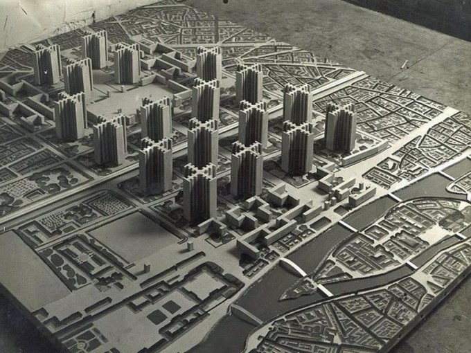
Proposal for Paris by Le Corbusier
“A City made for speed is made for success”
-Le Corbusier (The City of Tomorrow and its Planning)
The plan proposed by Le Corbusier was conceived around strong notion of center. The city center was conceptualized to be constructed vertically to reduce the distances to be travelled. The residential quarters were to be built away from the transit corridors. According to Corbusier, the modern street is a new type of organism. For Corbusier, streets are mechanisms to layout the services across the city, like gas, water and electric mains. Further down the line he says, the streets are pivotal in social life as well as economic exchange and the security purposes. He says, all the streets should be accessible from ground level in order to enhance the beauty of the street along its length. The critical aspect of his plans were the road network of it. As Corbusier was fascinated with ships, liners and cars, in his proposals one can see the dominance of machines over humans. He segregated the pedestrian movement from the vehicular one to allow the vehicles to move faster. The notion of geometrical axes of the city on North – South and East – West direction leading to the city center and building the city around the core were key ideas in his proposals. The city in Corbusier’s proposal represented could be categorized in cosmic diagram as per Spiro Kostof’s City Shaped. The city followed strong hierarchical order in terms of class, function and population.
Corbusier, in his proposal for Paris and Chandigarh puts emphasis on laying out pure geometrical grid by saying, city is dying because it is not geometrical. He says city will need a uniform layout in place of haphazard arrangements. This rigid geometry means repetition. This concept of repetition connects its dots with the standardization. A standardized grid was a perfect solution for the city of tomorrow according to him.
Simultaneously if we have a look at the proposal by Frank Lloyd Wright for Broadacre City, Lloyd Wright tried to respond to the suburbia and develop a utopian neighborhood where the American families would own an acre of land to reside and use private motorcar to commute across the city. One can say that this was exactly opposite to transit oriented urban morphologies because Lloyd Wright’s neighborhoods had commercial and offices along with the residential districts. This is strikingly opposite to the proposal given by Corbusier for Paris and La Ville Radieuse. On one hand Corbusier is talking about tall buildings in large open gardens and on other end, Lloyd Wright is proposing a utopian suburbia in open field.
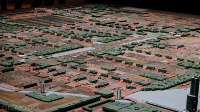
Model of Broadacre City by Frank Lloyd Wright
Although both the models proposed designs keeping mobility in center, they are very distinct in the lifestyle they offer. Corbusier’s City of Tomorrow puts importance on finite boundary of city to stop the city growing endlessly and having tall buildings to house more population and wide roads to cater to fast moving traffic. Lloyd Wright’s Broadacre City has other prospect of city where he is trying to decentralize the economic exchange from the city center and he is trying to develop neighborhoods free from the political construct and able to flourish on their own.
Cases in India:
We can relate these cases with live cases of India and see how mobility has affected the design and how the authorities have built on it further. If we look at case of Gurgaon, the city is located on south of NCR Delhi. The city started growing around the existing village and the city witnessed rapid urbanization in and around the village. The reasons behind it could be the well-knit network of mobility. The city today is integrated to Delhi and Haryana through metro lines and rapid transit corridors for fast moving traffic. Although the city is 32 km away from urban development area of NCR Delhi and 268 km away from Chandigarh, the integrity of the mobility allowed the precinct to take up urban form and allowed economic exchange to happen. In 1970, Maruti Suzuki established their manufacturing plant in Gurgaon. This encouraged migration towards the city. The city has developed in 36 wards which are further divided in blocks. The neighborhoods and their connectivity with other parts of the city played pivotal role for the city to grow at fullest. The workers of factories like Maruti Suzuki and DLF Cyber city got adequate mobility options to travel across the city.
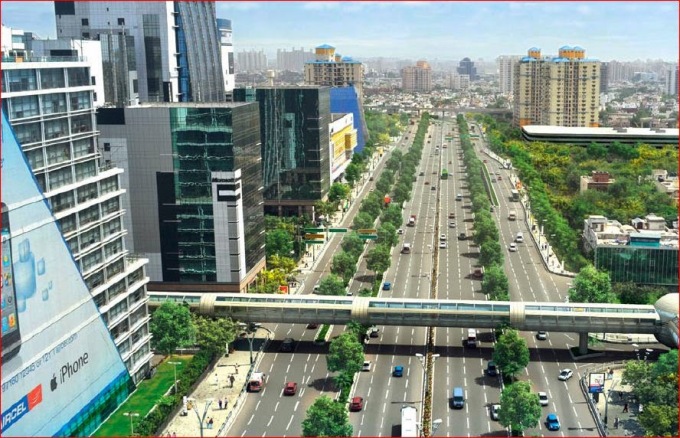
DLF Cyber City, Gurgaon
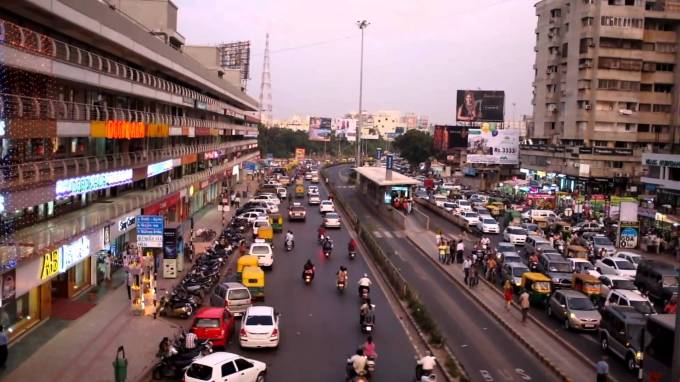
Another case we can discuss here is Mumbai. In a city like this where population of the city grew by 80% in time of thirty years, the mobility in city becomes crucial parameter in city’s living. The number of migrants to Mumbai from outside Maharashtra during the 1991–2001 was 1.12 million, which is to 54.8% of overall population of Mumbai. As they rightly say, local train is lifeline of Mumbai, the suburban railway network has 7.5 million commuters daily which is 40% of overall population of the city. In addition to that, as the figures say, 4.5 million people commute by bus which is another 25% of overall population of the city. The city as we know has been sitting on reclaimed land in sea. The city has grown across the sea coast and also has started sprawling towards east. The city has existing three major spines of suburban railway network. Western line which connects Church Gate to Dahanu Rd linking kandivali, and virar. Central line which links Chatrapati Shivaji Terminus to Kalyan and third is Harbor line which connects CST to Panvel and Andheri. This wide spread network of suburban railways is so deep rooted in the anatomy of city that it connects two extremes of the city and the urban life becomes dependent on the transition. The parallel network of movement which is functioning in the city is local buses. In addition to buses the city has cabs, auto rickshaws and private vehicles.
These mobility options act as gear of machine and they play pivotal role in the working of the urban mechanism. If we go with this figures, people travel every day from north and east Mumbai towards the fort area and southern Mumbai. These people who come to work every day, go back to north and east Mumbai at night. This mass transition of people defines a peculiar type of urbanism for the city. If we see the morphology of the city, major urban developments have happened along the railway lines. In a way suburban railway lines are becoming the means of defining the territory of the city. The distances between places starts to be measured in time required for a local train to reach. This railway tracks leave another mark on the urban fabric. They cut through densely packed urban fabric and they leave ‘shadow lines’ behind them. They divide the city in two major territorial fragments. Current city of Mumbai faces that differentiation of class and economy in east Mumbai and west Mumbai which are demarcated by the suburban railway lines.
As the city is highly dependent on these public transport system and the system is integrated in routine of Mumbai lifestyle, absence of any of these ‘gears’ may result in collapse of the urbanism. The urban life may come to a halt. We also evidences of the same regarding the same. In cases of emergencies and natural calamities like floods, the railway cannot operate, the life comes to a halt and city faces a huge consequence. One can also say that it is dangerous to have so much dependency on a transport system. In 2012, Mumbai suburban railways were made the target for terrorist attacks. This shook the whole city. This dependency of urbanism on one mechanism can control 19 million people should be re-thought.
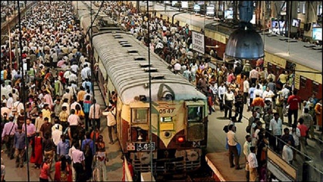
Busy Railway Station at Thane
Now we take a look at medieval time stamps. Ahmedabad is classic case of urban transformation. The city has evolved from a feudal city to contemporary urban fabric. The city originated on banks of perineal river of Sabarmati. Medieval town of Ahmedabad grew around the social structure and an organic urban emerged out of it. This medieval town was thriving on trading of the spices and exotic goods along the silk route. The fortified city then from Mughal Empire went under the British Raj. The British rulers left the medieval urban fabric untouched and started setting up their settlements outside the fortified city near the today’s Shahibaug area. They started making their colonies and cantonments outside the walled city. Because of the industrial revolution, textile industries nurtured in 19th century. These textile mills gave employment to thousands of people across the state. People who were in search for an economic opportunity rushed towards the city. As the census data says, the city saw average population hike of 40% every decade. The city continued to grow in radial manner and newly migrated population started settling around the city. The city flourished around mercantile business. As every other typical medieval city, Ahmedabad’s power center shifted from ruler to the merchants. These merchants laid out many infrastructure for public realm from the surplus of trading business of textile. During British raj, Ahmedabad being epicenter of economy in India then, it was well connected with other parts of India through rail network. The shift from British raj to democracy changed the city morphology. The city today has grown with co-centric rings and radials leading towards the city center. Traditionally people used city bus known as AMTS to commute across the city. The mass transit as followed the morphology of the city and most of the routes originated/terminated at the commercial center of the city. Later in 2009, Municipal Corporation introduced decentralized rapid transit system. As per official data from BRTS – Ahmedabad, on average 1,30,000 people travel in BRT on daily basis which makes just 2% of the overall population. This will leave anyone with a question. The transport system which was envisioned to take major share of public transport is not welcomed to its optimum limit. The amount of urban infrastructure which was laid to make this work may not be giving justice to the same. Major population of the city commute by private vehicles. The municipality then came up with a strategy to promote public transport. They started allowing more floor space index leading to higher density of people along the BRTS corridors. Consequence to this remains uncertain.
An underused rapid transit corridor in chaotic spine of Ahmedabad
Cases around the Globe and the turn over:
The large question here is what drives what? Is the mobility following the urban morphology or mobility is being followed by the urban form? This cases across the country leaves us thinking in today’s context and how do we foresee the city coming on board. Let’s throw some light on live cases outside India. We will simultaneously take support of some literature here. In mid-20th century, New York and many other cities went through mass disruption due to world war. The municipal authorities were building cities again. Authorities were trying to meet the needs of rapidly growing population. The industrial revolution had also affected the life in cities and automobiles had started pouring in. There was a major shift in the notion of the street and the way streets behaved before the vehicles came into existence. The streets which one used to perceive as public space changed to major artery for transition and mobility. The machines had started taking over the public realm. The vital character behind this model was Robert Moses, the town planner and master builder of New York. Robert possessed authority of developing urban parks and transit oriented bridges and flyovers. Robert was influenced by modernist ideas of Frank Lloyd Wright and Corbusier for the post world war city planning policies.
Robert Moses aiming at industrial development, imposed his modernist ideas on urban fabrics of American towns. Robert started laying ‘functional’ network of transport oriented streets and a development plan targeting towards economic growth. This gave incentive to private industries to nurture in this capital centric environment. This moves by Robert almost killed the ideas of neighborhoods and what he achieved was a virtual maze of highways which cut through the life of people.
In 1961, people started questioning high modernism and started looking for postmodern concepts. Jane Jacobs was a journalist, author and activist who tried to raise her voice against the capitalist evolution of the urban lifestyle in American cities. Jane Jacobs started questioning the modernist ideas of Robert Moses. She started from scratch and projected issues in Robert’s Cities at grass root level.
Jane starts defying the modernist impression of Moses and challenges his approach of design guidelines in multifaceted manner. She in a way becomes advocate of common people and tries to caricaturize a human centric approach rather than a machine driven approach for urban planning. She also lays down a conceptual framework for drafting out human centric approach of urban design where she talks about mixed land use to improve quality of life, high density with smaller urban blocks to ensure walkability. She also puts emphasis on concepts like social capital and eyes of street.
One can point out this binary opposition prevailing in American society. One can relate this topic with the colonizers and the colonized. The duality which dictates the vision for the city. One can call it the dichotomy between the social (the left) and the economic (the right) where there is a constant struggle for judgement between human centric approach and technocratic approach of envisioning our cities.
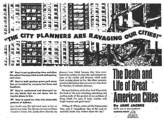
Jane Jacob’s Reaction to Robert Moses’ Development of New York
Now if we look at the case of medieval town of London, it has been through many transformations over a period of time. The city has been through casualties like great fire, plague and world war. In all these phases the city almost collapsed. The city was rebuilt brick by brick each time it collapsed. Through these transformations one thing that is significant is its location. The city was re-built on the same site and not leaving it to die. A few structures which remained over time were the tower of London and St. Paul’s Cathedral. The topography of the city could be deciphered into three major elements. First and the most powerful element is the Thames River dividing the northern and southern London with its serpentine riverbed. Due to some events in history, major important places are sited in northern part of the London. The southern London is designated as a densely packed residential district with a vast network of thoroughfare. Moreover, London has variation across east to west. The flow of water and the wind is towards eastern part of England. This feature led to mills, shipping, industries towards the east and the high end residences and places for leisure grew in the western part of the London.
We can identify a strong axis being formulated in the walled city of London from St. Paul Cathedral and the tower of London. The road network was established going across the Great Britain. London city then grew around this major road network. The division of eastern and western London is marked precisely in the urban fabric of London and also the people have adopted the same. Slowly this division started losing its impact because the industry buildings were demolished and offices and residential districts came up in that region. If we look at the London’s growth over history through these distinct zones in cardinal directions, we can decipher that it has a simple circular route which defines the growth in radial manner. The epicenter of this co-centric rings is the historic walled city of London spanning across 2.8 square mile. Which has the Municipal Corporation, Offices and other Public Buildings. The immediate concentric ring to this area is a suburban belt. This suburban belt was developed during late 18th century to the beginning of the World War 1. In this suburb area we can majorly see residential buildings with terraces and these residences are scaled in a manner which they look intimate and domestic. We can identify some out of proportion buildings which were made at the damaged sites of the World War 2 by the local authorities. The final co-centric ring is called the Outer London, which was built in 20th Century as suburban housing district. This district was erected with a great speed during 1925-39 AD. This belt has mostly semi-detached residences. These residences are a perfect blend of raw house and free-standing house. The conclusion to the concentric rings is the Metropolitan Green Belt. It gives the form to the whole capital.
Today’s London operates on multiple levels of transports. It is a classic case of public transport which one can relate with case of Mumbai. Due to his co-centric growth of city, London has transit pattern similar to Mumbai. People commute to city center in morning and come back to their residential suburbs in evening. So in evening the city core becomes empty and almost dead. Out of London’s 8.5 million population, on average 4.2 million people commute by underground metro and daily, which is 50% of overall population of the city and 1.4 million people commute by over ground metros and black taxi. The statistical data says, in past few decades, the number of private car owners has decreased significantly and it has continued to fall further from 1.04 cars per people to 0.7 cars per person. This significant fall was a result of municipality’s decision to take congestion charge from the private car owners. Despite of having well integrated road network the authorities are promoting pubic transport to improve the street character and road safety.
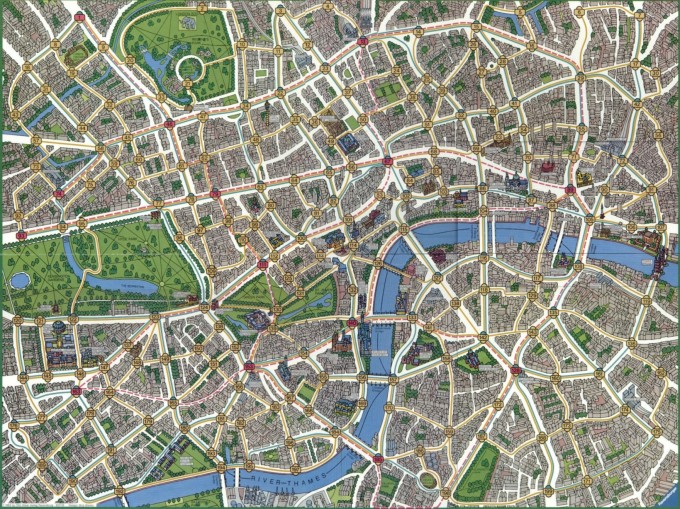
Illustration of London Transit Map for Scotland Yard Board Game
The Strengths and the Weaknesses of Mobility driven Urban Fabric:
From the cases we discussed above we can fetch some derivations out of it. The city conceptualized around mobility can be deciphered from the morphology of the urban fabric. There are two distinct characteristics of such planning strategy. One model has a densely packed city core which constitutes the economic city center and wide spread urban sprawl around which houses the residential and institutional districts. This model witnesses major population moving from one part to the other part of the city every day. This model offers promise of a peaceful living environment and pollution free neighborhood which is away from the hustle and bustle of city. It has On the other hand it has a few drawbacks also. It makes city economy highly dependent on the mobility. This dependency of urban life on mobility could be fragile for a city. It is a delicate situation for a city and outer force can shatter an urbanity from this one factor. Another critical aspect of such urbanity would be quality of life in city. At peculiar time in a day, some parts of the city may start becoming dead. According to Kevin Lynch, this peculiar model of urban form is ‘made up of small autonomous, undifferentiated parts, linked up together in to a great machine which in contrast has clearly differentiated functions and motions’. For Lynch this model is Practical or Functional in his morphological studies of the cities.
If we try to envision the other model where there is absence of physical center of city, the decentralization of economy reduces the distance to be traveled. This model sits in contrast to the practical model. It starts acting as an organism. As Lynch puts it forward, this model has ‘a finite boundary, an optimum size, a cohesive, indivisible internal structure and a rhythmic behavior that seeks, in the face of inevitable change, to maintain a balanced state’. If we try to look at advantages of this model, this model is integrating multiple functions in a neighborhood. On the other hand this model creates enclaves which brings out territoriality. A residential district with economic opportunity in a neighborhood may reduce everyday traveling time and distance for a worker. At the same time, if factories and mills start emerging in neighborhoods, people will start compromising with the quality of life.
While designing for mobility, there is always this binary opposition which prevails. If we go back to Jane Jacobs’ argument of quality of life being lost in modern transit oriented cities, metro cities with huge population start losing the neighborhood environment. On other hand the modernist, mobility oriented model may stand true on promise of huge surplus due to the concept of functional differentiation and mass production. To close I would say while designing for mobility, the urban designer shall double check the viability of the nature of mobility he/she is proposing. Considering the fact that people commute regularly to work, shop or leisure, mobility today could be envisioned as artery to the urban anatomy. The flow of population through these arteries become critical when this movement becomes anomalous and starts disturbing the urban life because these movements are unpredictable if it is not backed up with adequate groundwork.


